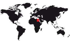
Egypt, or rather the Arab Republic of Egypt to give it its official name, is above all the isthmus that links Africa to Asia. Pinched between the eastern Mediterranean and the Red Sea that sinks into the land like a corner, the territory of this country seems to have splashed to the sides. With its form of asymmetrical sack, it covers on the one hand the northeast corner of the African continent and on the other an appendage of the Arabian Peninsula, Sinai, which already belongs to the Asian continent. In addition to this intercontinental passageway, there has been a maritime link between the Mediterranean and the Red Sea since a canal was cut through the Suez Isthmus. Is it enough to say that Egypt, land and sea crossroads, occupies one of the most strategic areas of the globe?
Borders
Adjoining Libya, to the west, along a border lost among the sands of the desert, Egypt shares another with Israel, at the root of the Sinai Peninsula, from the Gulf of Aqaba to the Mediterranean.
Towards the south, a third border drawn perpendicular to the Libyan border, between Jebel Uweinat and the Red Sea, separates Egypt from Sudan. Egyptian territory covers a total of one million square kilometers.
The preeminence of the Nile
The African part of Egypt forms a vast quadrilateral that the Nile shares in its middle, from south to north. Its lower course traces a clear corridor that comes from the steppes of Sudan and reaches the Mediterranean. The Nile is at the same time the axis of the country, its navigable way, its vital artery and its pole of activity. Herodotus went even further when he asserted that "Egypt is a gift from the Nile". Maybe it's exaggerated. But what is certain is that the Nile Valley is home to most of a population of 96,000,000.
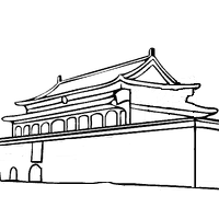
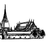
On the very banks of the river, Cairo, which reunites 5 million people and nearly 9 with its suburbs, is not only the capital of Egypt; it is also the most populous agglomeration of Africa.
Climate of Egypt
Nature seems to be trying to make Egypt a desert. As a result of its geographical position, this country is in fact almost entirely in the arid tropical zone.
While it is true that the southern end of the Mediterranean climate zone, characterized by winter rains, concerns the north of its territory, it concerns only a tiny coastal fringe. For the rest, the numbers speak with terrible eloquence. Those who express precipitation, for example. These are still of Mediterranean type in Alexandria, but already fall to 50 mm in the middle of the delta of the Nile, that is to say to less than 100 km towards the south. In Aswan (Aswan), at the southern tip of the country, rainfall is almost non-existent, less than 1 mm of water a year.
If you look at temperatures now, you can see that the heat increases steadily as you go south. The annual average of Alexandria is 20.7 ° C; that of Aswan of 25.8° C.
Under these conditions, it is not surprising that most of Egypt is made up of deserts.
Seasons
Despite a certain degree of drought, the Egyptian climate is shaded by seasonal variations. The beginning of spring (February-March) is a cool period, with the rare rains washing the sky at the same time as they moisten the soil. April, on the other hand, is the hateful month in which the khamsin blows. Coming from the desert south, this wind spreads over Egypt its burning breath and laden with sand. It usually occurs during much of March and the whole of April, hence its name, "the wind of fifty days". Characterized by incredible violence, day and night, the khamsin darkens the sky and seeps everywhere. Air traffic is severely disrupted as a result of unexpected changes in flight schedules, the imperative diversion of airplanes to temporarily spared aerodromes and even air disasters.
Heat increases in May, raises crops, and flambers the flamboyants.
The hot Egyptian summer in Cairo is more bearable in Upper Egypt thanks to the extreme dryness of the air. This heat, very strong, raises fogs on the shores of the Mediterranean and the Red Sea.
Fall and winter are a long, cold time. It is the best for tourists.
Nature
With the exception of the Nile Zone, the natural vegetation of Egypt is poor. Some grasses such as "drinn" and thorny trees such as acacia, in the bed of wadi (wadis) and dry valleys, are the rare evidence of the plant kingdom in an essentially mineral world.
The absence of continuous plant cover aggravates the thermal differences on the ground, therefore, contributes to accentuate the aridity of these territories.
Geology
From a geological point of view, Egypt as a whole depends on the old crystalline base of the African continent. It is from this bedrock and its granitic inclusions that the Egyptians of the Pharaonic period extracted the materials allowing their temples to brave the millennia. Secondary sediments, Nubian sandstones, cover the base over a large part of its surface. They are themselves surmounted by limestones and nummulitic of Cretaceous age. These limestones were more or less raised and broken by the orogenic movements consecutive to the stretching of the African lithospheric plate. Thus the mountainous massif of Sinai must be considered as an isolated horst between two large tectonic fractures, the Suez gap and that of Aqaba. Yet the Sinai horst has been powerfully raised to the south where its altitude reaches 2637 m at Jebel Moussa, in the Mont-Sainte-Catherine massif, while its reliefs plunge north under sedimentary plateaus, themselves modeled in cuestas.
West of Sinai, the African shield was bulged, then collapsed, forming the Red Sea ditch. From this bulge, only the root remains: on the eastern slope of the moat, its raised foundations rise up to 2,100 m thanks to asymmetrical reliefs sometimes called the Arabian chain.
Still further west, the Libyan plateau spreads its flat horizons to uncertain boundaries where aridity has been aggravated by the gradual burial of water beneath permeable sediments. This desert is one of the few areas of the globe where climatic aridity adds to an aridity of karst origin. A desert quintessence.
In these conditions, it is understandable that the Nile alone is the clearest to the hydrological network of Egypt. Its waters from Equatorial Africa cross Egyptian territory like a strangeness of passage, like a kind of epiphenomenon in the midst of aridity. And we immediately guess the vital role played by this artery for the whole country.
Past Cairo, the great river enters its delta, postglacial construction which continued to progress during the historical period.
Is this an area still expanding? it seems no. The expansion of the Delta now seems blocked. For two reasons. First the underwater soil has a steep declivity and steep slope, difficult to fill. In addition, a strong current sweeps the coastline and scatters the alluvium.
As it stands, the Egyptian territory is logically divided into four zones with obvious boundaries: the Nile valley, the Libyan desert west of it; the Arabian desert between the river and the Red Sea; finally the Sinai Peninsula.
Regions that all have a special appeal and keep assets to promote the development of present-day Egypt.
Rregions
The Nile and its valley
"You created the Nile from the underworld and made it come forth at your pleasure so that men live, you, their Lord!" Declared Pharaoh Akhenaton to the sun god in his magnificent "Hymn to the Sun."
At all times, the life of Egypt has been settled on the Nile. Today, at the entrance to Cairo, a nilometer reconstructs the masonry well graduated 4,000 years BC with the help of which the ancient Egyptians watched the vagaries of the river. The Nile began to rise in June. In the second half of July, its waters swelled significantly and the level reached its maximum end of October. The recession then spread until January. Then the river went back to bed.
Fertilizing, receding and low-water floods set the pace for a concentrated agricultural life in the river valley.
Even today, the presence in the middle of the desert zone of Egypt's enormous population accumulation is due exclusively to the influx of water from this great collector of Africa.
Huge contributions, by the way. The average flow of the Nile is 2,500 m3 / s in Aswan (Aswan) and its maximum flood reaches 8500 m3 / s. These waters come from the tropical rains that fell on the highlands of Ethiopia and on the plateau of the lakes of East Africa. Because, if the river came, according to ancient belief, underground reservoirs near Cataract and guarded by Khnoum, the ram-headed god, we now know that the Nile arrives from Lake Victoria through Uganda and Sudan. , receiving in Khartoum the Blue Nile, its main tributary, which comes from Lake Tana, Ethiopia.
Egypt has only the lower course of this 6700-kilometer-long river. On the Sudan-Egypt borders, the natural course of the Nile is cut by cataracts, simple rapids numbered from 1 to 6 in the downstream-upstream direction. This modest break in the river's slope has been modified by the construction of the Aswan High Dam, located upstream of the cataract. Lake Nasser, that is to say, the colossal reservoir that has resulted from this work, drowned pure cataracts upstream.
Downstream from Aswan, the course of the Nile widens significantly. The river flows with majesty in a wide valley on average of 20 to 30 kilometers. From Cairo, finally, the Nile enters its delta, vast alluvial plain eminently fertile, which extends on 200 kilometers. Circulating in the middle of these flat lands, carrying rich cultures, the Nile leads to the sea by the only two currently active branches of the Delta: the branch of Rosette and that of Damietta, with the respective modules of 1 076 and 508 m3 / second.
Dams
For a century, the Nile has seen its course transformed by major works: building dams to raise the water, especially in the Delta; creation of dams and reservoirs to improve the flow during low-water periods, in Aswan, Jebel Aulia and Sennar. Finally, near Aswan, the high dam, built from 1960 to 1964 and whose impoundment was completed in 1972, is one of the largest in the world.
The interest of Egypt in irrigation development and the advantage of hydropower production are at the origin of this work. Of course, this artificial cut has removed the great annual palpitation of the flood and the recession of the river, thus changing the millennial pace of rural life installed on its banks. Even the climate is affected. At present, short but torrential rains, fed by the evaporation of this inland sea, sometimes come down on Upper Egypt.
The Libyan desert and its oases
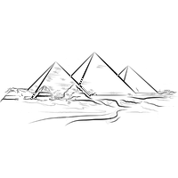
To the west of the Nile Valley, the Libyan desert, or western desert, opens up to the horizon its landscapes of the beginning of the world. For the geographers, it corresponds to the lowest steps of a vast Saharan staircase which descends by degrees from the Tibesti massif. To this stepped relief is added a series of collapses generating depressions. Curiosities of nature that these depressions of Kattara, Siouah, Fayoum or Wadi-Natroun (Wâdï al-Natrûn)! Their bottoms are largely below sea level. And, as if to remind us of the tectonic origin of their formation, their edges remain marked by the mirror of primitive faults, forming cliffs.
The shelf of the Libyan plateau, between 200 and 500 m altitude, excels in a series of basins, now occupied by oases. Their rosary, in which Baris, Kharguèh, Dakhla, Farafra and Bahriya are scattered, seems to represent the remains of a fossil course of the Nile, a route abandoned, it is true, since the Pliocene, that is to say, for several million years. years.
To get an idea of this desert area, we need to add to the overall image based on a stepped relief a more sectoral morphology linked to erosion phenomena. From north to south, the desert sees the rocky expanses of the Libyan plateau, the hamadas and dune systems of Ghard Abu-Mokhariq, the great sand desert, the rocky peaks rich in ammonites and, to the south, a mountain system announcing Tibesti.
This ensemble is the oldest arid zone of the Sahara. Its sterility stretching out to the west of the Nile made it quite naturally the "bank of the Dead" for Egypt's pharaohs. It would literally be empty of any human presence without the existence of the depressions that excavate the surface. The most northerly of them are below sea level and correspond to an aquifer level. Is it an underground water table or more ramified circulation? This is still a subject of debate for specialists. However, it seems that the water in reserve depends on fossil storage going down from Tibesti to the Mediterranean.
The existence of this underground water explains the source lines that give life to these depressions. The wealth of archaeological remains found in these basins and oases testifies to their ancient prosperity and their development by man since Antiquity.
"The sand has turned into cultivable land and that's how the universe came into existence" reminds us of a poem in hieroglyphs.
It is also known that the basin of Al-Natrun provided Egypt with pharaohs the sodium hydrated carbonate, which was then called netery, a word which meant "the divine" because it was used to mummification. Sign of the times, it is today the object of an industrial exploitation to feed the chemical industry.
The ancient irrigation system of the depressions has unfortunately been devastated by the Arab nomads. Today, Egypt is trying to repopulate these basins by multiplying boreholes. From now on, and without counting the Fayum basin which we must rather relate to the Nile valley, the depressions of the Libyque desert count more than 100.000 inhabitants.
In the dunes and rocky hamadas landscapes are added sugar cane fields in the Dakhla oasis and the cotton fields of the Kattara depression. Large development projects are aimed at these poor regions where Egypt can find to expand its arable land at the cost of gigantic sites.
On the northern edge of this desert, the Mediterranean coast brings a fringe of relative wealth with the development of coastal agricultural sectors and a zone of tourist facilities around Marsa-Matrouh.
The Arabian desert and its coast on the Red Sea
Another landscape that tells us about the dawn of the world, the rising of the Nile: the Arabian desert. This eastern desert is quite different from its western counterpart. More vast plateaus, dunes, collapsed ponds. Here we are in the presence of a real mountain range. It stretches itself even more than 800 kilometers, from the environs of Cairo to the border of Sudan, and culminates at more than 2,000 meters. Only tectonic movements can justify this local bulge of the African shield as well as secondary fractures that break the unity. The movement is ancient, but traces remain, these faults, very sharp, which isolate the Sahra Erh Sargieh, east of the city of Miniah.
Less visible, other fractures produced by local uprisings have risen to 1,000 meters above sea level and more mountains that streak along this mountain range: Jebel Niqrûb, Jebel Mamâta and Jebel Châ'ib, the highest point (altitude 2,187 m).
Of course, this mountainous layout shields moisture from the Red Sea. A relative humidity but which gives this furnace rainfall of the order of 10 to 25 mm per year. From these meager rains still results a temporary flow. And it is he who is at the origin of a normally hierarchical hydrographic network whose presence shapes especially the eastern facade of the reliefs.
As a result of their great geological antiquity, the bases of the Arabian desert contain some precious minerals such as gold or porphyry. Richness so well guarded by the darkness of the mine and the glow of the sun that this poor mountain was considered a fabulous mining region during Antiquity.
At the dawn of Christendom, only a few monastic congregations of the Coptic rite agreed to settle in this desert. There are still some Christian convents that provide the only sedentary human presence in these reliefs, traveled by nomadic tribes who are engaged in a pastoral economy of another age.
At the foot of the eastern slope of this mountain, the coast of the Red Sea is only a narrow coastal strip, crushed by the sun. Egypt, however, considers it as a planning area promised a bright future. In addition to the chemical complex (phosphates) Ham-rawein, this coast sees erect a series of seaside resorts and holiday villages around Hourghada.
Sinai, the promised land of tomorrow
This coastal fringe finds its counterpart on the eastern shore of the Red Sea. But the coastline stretching from the Suez Canal to Ras Munammad, the extreme point of the Sinai Peninsula, saw the rise of powerful industrial developments on its thin strip of flat land. Here align the oil wells of Soudr, Asl, Ras Matarma, Abu-Zenima, Abu-Roudeis, Belayim, July, Ramadan, Morgan, Shab-Ali; the Abu-Zénima manganese foundry, the Oum-Bogma (manganese) mines.
Seaside tourism only finds its chances on the other side of the Sinai peninsula, bordering the Gulf of Aqâba. Here, Egyptians inherited tourist facilities built by Israelis. A strategic square made famous by the six-day war, Sharm el-Sheikh has now become a tourist center.
As for the Mediterranean coast of the Sinai Peninsula, partially protected by a long coastline, it sees widening the Canal of Peace which must connect Port-Said (Bûr Sa'ïd) to el-Arich.
In the interior of the peninsula, the Sinai horst forms a mountain range raised around Mount St. Catherine (Jebel Katrina) and Mount Moses (Jebel Moussa) whose 2,641 m make it the highest point in the world. Egypt.
If its high reliefs give Sinai a strategic function whose recent conflicts have shown interest, geology has long made this mountain an economic issue; it was at the time when turquoise mines were feeding the goldsmiths of the Pharaohs. Subsequently, the very ancient Christianization of these reliefs - and especially the establishment of a convent on the alleged tomb of St. Catherine - has metamorphosed these desolate mountains into mystical peaks. Today, they are more attractive to hikers and trekkers.